
Dr. Yichuan Ma’s recent publication on ISPRS Journal of Photogrammetry and Remote Sensing
- Jul 3, 2025
- 2 min read
Updated: Jul 17, 2025
A universal physically-based topographic correction framework for high-resolution optical satellite data
Congratulations to Dr. Yichuan Ma on publishing a research article on ISPRS Journal of Photogrammetry and Remote Sensing. The title of the article is “A universal physically-based topographic correction framework for high-resolution optical satellite data” and it is now available at https://doi.org/10.1016/j.isprsjprs.2025.05.027
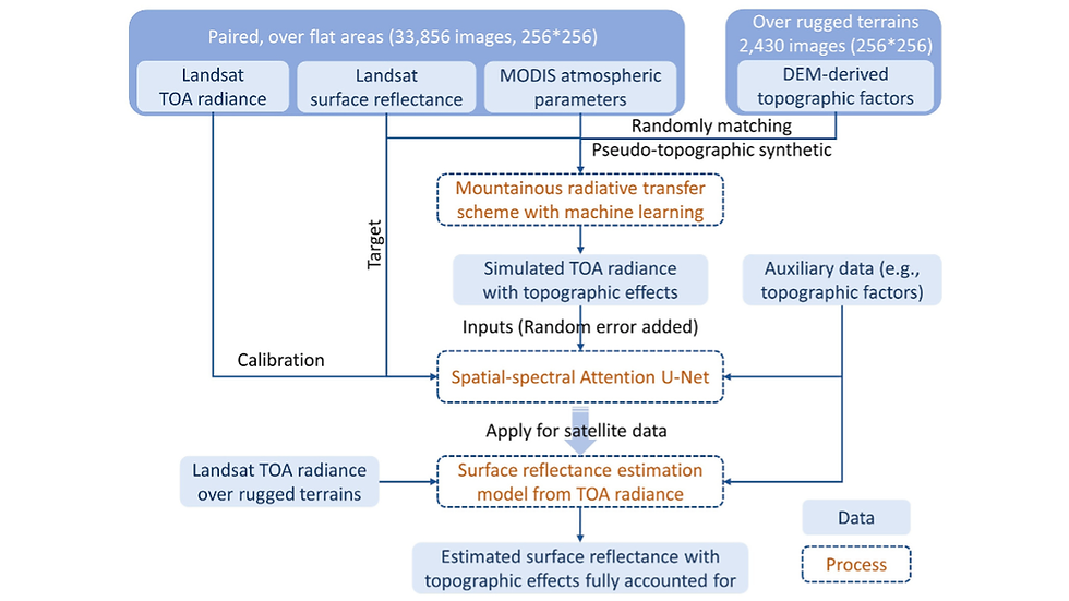
This study introduced a Universal Topographic Correction (UTC) framework, a physically-based approach designed for seamless integration with multiple high-resolution satellite and airborne datasets. The UTC integrates spectral information from extensive radiative transfer simulations with image-derived spatial information to optimize spectral direct irradiance ratios, a key component of physically-based correction, while accounting for shadow effects and digital elevation model (DEM)-induced errors through targeted processing along shadow boundaries. We evaluated UTC’s performance against established methods, including C-correction, SCS+C, and Statistical-Empirical (SE), using a 3D radiative transfer model as a reference across varied topographic and illumination conditions.
Results showed that UTC consistently outperformed these methods, particularly in shadowed areas, with mean absolute deviations in the near-infrared band of 0.0103 for UTC compared to 0.0179 (C), 0.0362 (SCS+C), and 0.0311 (SE). Testing across Landsat 9 (30 m), Sentinel-2 (20 m), SPOT 4/5 (10–20 m), PlanetScope (3 m), and AVIRIS-3 (~2.9 m) datasets further demonstrates UTC’s robustness, effectively reducing overcorrection in complex terrains and improving reflectance accuracy in shadowed regions. UTC’s advantages lie in (i) requiring no external atmospheric inputs, and (ii) its physically-informed design based on spectral and spatial information for broad applicability. This study underscores critical limitations in existing topographic correction methods and proposes a robust solution for addressing them.


Reference: Ma, Y., Liang, S., Peng, W., He, T., Ma, H., Chen, Y., Li, W., Xu, J., & Guan, S. (2025). A universal physically-based topographic correction framework for high-resolution optical satellite data. ISPRS Journal of Photogrammetry and Remote Sensing, 227, 459-480
Keywords: Topographic correction; Surface reflectance; Radiative transfer model; Landsat 9; Sentinel-2; SPOT; PlanetScope; AVIRIS-3


Comments